
Hurricane Michael approaching; voluntary evacuation order issued
Posted on October 8, 2018
UPDATE: Monday, Oct. 8, at 3:30 p.m.
In addition to the previously announced closures, CDI Head Start will be closed Tuesday through Thursday, as will Aucilla Christian Academy.
Non-essential City of Perry offices will close Tuesday, although the exact time will be determined by the weather conditions.
The Perry City Council meeting scheduled for Tuesday has been canceled. The Taylor County Commission workshop set for Thursday has also been canceled.
PREVIOUS:
The Taylor County Commission has issued a voluntary evacuation order for the county’s coastal and low-lying areas and expect that could be upgraded to a mandatory order on Tuesday with Hurricane Michael making its way toward the Florida Panhandle and a potential Wednesday landfall.
The commission held an emergency meeting Monday at 12 noon, voting unanimously to declare a local state of emergency, matching the one already declared by Florida Gov. Rick Scott.
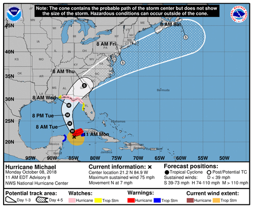
According to the National Weather Service (NWS) in Tallahassee, forecasters are calling for a 9- to 11-foot storm surge Wednesday if the hurricane hits at high tide, which will be around 4 p.m.
Taylor County Emergency Management (TCEM) Director Chuck Mincy told commissioners that weather forecasters are telling them to expect a strong Category 2 (96-110 mph) or Category 3 (111-129 mph) storm, and to prepare for a Category 4 (130-156 mph) storm.
Evacuation orders
The county’s voluntary evacuation order is now in effect, and the commission authorized Taylor County Sheriff Wayne Padgett to issue a mandatory evacuation order should the need arise.
At Monday’s meeting, Mincy said it was his recommendation that the county wait to issue the mandatory order until the emergency shelter was open.
County Commissioner Steve Spradley said he had been notified by Tri-County Electric Co-op officials that they will begin pulling meters along the coast at 8 a.m. Tuesday.
Schools to close; shelter to open
Taylor County Schools will be closed Tuesday through Thursday in light of the storm, as well as to make their facilities available for Red Cross shelters.
The primary shelter will be at Taylor County Elementary School and will open Tuesday at 2 p.m. An overflow shelter will also be available at Taylor County High School.
According to TCEM Deputy Director Kristy Anderson, the shelter will take pets as long as they are crated.
In addition to schools, non-essential county offices, as well as the county courthouse, will close at 12 noon Tuesday. When asked about city officials, City Finance Director Penny Staffney said they were meeting at 2 p.m. today to decide when offices will close.
Sandbags available
Sandbags are now available in Perry at the County Road Department on U.S. 27, with a limit of 25 bags per person.
Sandbags will be able at the Steinhatchee roll-off site as soon as materials are brought to the site.
Weather update
The NWS has issued a hurricane watch for much of the Florida Panhandle and Big Bend area, including Taylor County.
According to the 11 a.m. update from the National Hurricane Center, Michael, which was boasting maximum sustained winds of 75 mph, was about 50 miles south of the western tip of Cuba, moving toward the north near 7 mph.
“A northward motion at a slightly faster forward speed is expected through Tuesday night, followed by a northeastward motion on Wednesday and Thursday,” forecasters said. “On the forecast track, the center of Michael will move northward near the western tip of Cuba this afternoon and into the southeastern Gulf of Mexico by tonight. Michael will move across the eastern Gulf of Mexico Tuesday and Tuesday night, and is expected to move inland over the Florida Panhandle or Florida Big Bend area on Wednesday, and then move northeastward across the southeastern United States Wednesday night and Thursday.”
Subscribe to our e-Edition and read the rest of the story. Already a subscriber? Click here to sign in.
Recent Comments