
Taylor braces for impact
Posted on October 9, 2018
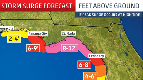
With forecasters calling for an 8- to 12-foot storm surge along the Taylor County coast on Wednesday due to winds associated with Hurricane Michael, local emergency management officials issued a mandatory evacuation order Tuesday morning for all coastal and low-lying areas in the county.
Sheriff Wayne Padgett issued the mandatory evacuation order shortly before noon on Tuesday and said deputies would begin notifying residents as soon as possible, Taylor County Emergency Management (TCEM) officials said.
Buses were stationed at Steinhatchee School and the Keaton Beach boat ramp to help shuttle people to the Red Cross shelter at Taylor County Elementary School, which opened at 2 p.m. Tuesday.
According to TCEM Deputy Director Kristy Anderson, the shelter will take pets as long as they are crated. An overflow shelter will also be available at Taylor County High School, if needed.
Taylor County’s public and private schools closed Tuesday and will remain closed through at least Thursday, with officials stating they are waiting to make a decision about Friday.
Most non-essential government offices in the
county — including the courthouse — closed at 12 noon Tuesday.
The Taylor County Commission met Monday to declare a local state of emergency and issue a voluntary evacuation order — giving Padgett the authority to upgrade the order later if the need arose.
Taylor County is currently under a storm surge and a hurricane warning, as well as a tropical storm warning further inland.
According to the latest warnings issued Tuesday afternoon from the National Weather Service (NWS) in Tallahassee, there is the potential for 8 to 12 feet of storm surge along the Taylor County coast.
High tides at Keaton Beach are 2:47 a.m. and 3:32 p.m. Wednesday.
Additionally, winds are forecast to peak at 30 to 40 mph with gusts as high as 55 mph.
Inland, winds are forecast to peak at 15 to 25 mph, with gusts of up to 35 mph.
The National Hurricane Center (NHC) is predicting Hurricane Michael will make landfall around the Mexico Beach-Panama City area Wednesday afternoon as a major hurricane, but everyone is warned to keep up to date with any late changes to the track.
As of Tuesday afternoon, the storm, with maximum-sustained winds of 110 mph, was located 335 miles south of Panama City moving north at 12 mph. Hurricane-force winds extended outward up to 35 miles from the center and tropical-storm-force winds extended outward up to 185 miles.
Mexico Beach, Port St. Joe, Apalachicola, St. George Island and the areas surrounding St. Joseph Bay and Aplachicola Bay were expected to receive the worst effects of the major hurricane beginning Wednesday morning and into the afternoon.
According to the NHC forecast, a northward motion was expected to continue through Tuesday night as it moves across the Gulf of Mexico, followed by a northeastward motion on today and Thursday.
“The center of Michael is then expected to move inland over the Florida Panhandle or Florida Big Bend area on Wednesday, and then move northeastward across the southeastern United States Wednesday night and Thursday, and move off the Mid-Atlantic coast away from the United States by Friday,” forecasters said.
Subscribe to our e-Edition and read the rest of the story. Already a subscriber? Click here to sign in.
Recent Comments