
Hurricane Michael strengthens to Category 4 with 145 mph winds
Posted on October 10, 2018
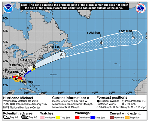
Hurricane Michael has strengthened to a major Category 4 hurricane with maximum-sustained winds of 145 mph and the storm is forecast to result in major storm surge of 9 to 13 feet along the Taylor County coastline today.
Local residents have already reported higher-than-normal tides Tuesday afternoon and overnight this morning, flooding boat ramps and reaching some low-lying houses. The next high tide will be 3:32 p.m. today at Keaton Beach and 3:38 at Steinhatchee.
Rains bands from the storm have reached Taylor County and the weather is expected to continue to worsen as the storm approaches landfall around Panama City-Mexico Beach area, making it one of the strongest hurricane ever to impact the Florida Panhandle.
Taylor County remains under storm surge, hurricane and tropical storm warnings, and a tornado watching has also been issued by the National Weather Service (NWS) in Tallahassee.
According to NWS forecasters, Taylor County expected to receive sustained winds of 35-45 mph with gusts to 55 mph along the coast and sustained winds of 25-35 mph and gusts to 45 mph inland (this is an increase from yesterday’s forecasts).
Recent Comments